


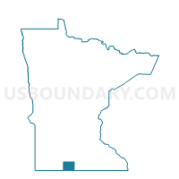
Ormsby Voting District, Martin County, Minnesota
About
Outline

Summary
| Unique Area Identifier | 603112 |
| Name | Ormsby Voting District |
| County | Martin County |
| State | Minnesota |
| Area (square miles) | 0.10 |
| Land Area (square miles) | 0.10 |
| Water Area (square miles) | 0.00 |
| % of Land Area | 100.00 |
| % of Water Area | 0.00 |
| Latitude of the Internal Point | 43.84716160 |
| Longtitude of the Internal Point | -94.69722010 |
Maps

Graphs
Select a template below for downloading or customizing gragh for Ormsby Voting District, Martin County, Minnesota


Neighbors
Neighoring Voting District (by Name) Neighboring Voting District on the Map
- Galena Twp. Voting District, Martin County, MN
- Long Lake Twp. Voting District, Watonwan County, MN
- Ormsby Voting District, Watonwan County, MN
Top 10 Neighboring County Subdivision (by Population) Neighboring County Subdivision on the Map
- Long Lake township, Watonwan County, MN (338)
- Galena township, Martin County, MN (248)
- Ormsby city, Watonwan County, MN (75)
- Ormsby city, Martin County, MN (56)